In the midst of an interesting post about historical versus pseudo-historical settings at Semper Initiativus Unum, Wayne includes a link to the International Catacomb Society, an organisation "dedicated to the preservation and documentation of the Roman catacombs [and] those rare vestiges of history that illustrate the common influences on Jewish, Christian, and Pagan iconography and funerary practices during the time of the Roman Empire." The site includes an interactive map of Rome showing the locations of various catacombs around the city in relation to other landmarks as well as floor plans of a small number of Roman catacombs.
Catacombs and other subterranean infrastructure, such as quarries and sewers and even human settlements, are 'dungeons' I don't feel funny about including in a historical roleplaying game campaign. They are wonderful settings for everything from covert entry to buried treasure, and I look forward to getting the characters in my campaign into someplace like the maze of passages beneath Paris - which won't exactly be catacombs for another couple of centuries - at some point in our campaign.
Who says the fantasy players should have all the dungeon-crawling fun, huh?
I added a link to the International Catacomb Society to the Ports o' Call collection of intreweb eclectica at the bottom of the right-hand column of RBE.

Showing posts with label map. Show all posts
Showing posts with label map. Show all posts
Thursday, August 22, 2013

Monday, March 12, 2012
If You Rolled a Seventeen . . .
. . . on the Field of Honor table, here's a map for you.
With the added bonus of a catacomb underneath.
With the added bonus of a catacomb underneath.
Monday, March 5, 2012
Another Historic Map Resource
The other day I wrote about the Carte de Cassini which I use as one of the campaign maps for my Flashing Blades campaign.
Today Paul at Quickly, Quietly, Carefully linked an absolutely amazing resource for any gamers running historical roleplaying games and anyone who feels joy at the sight of a map.
In about a minute I found an incredible map of Piedmont and Monferrato, where the action in our campaign is currently taking place.
Wow. I'm gonna have some serious fun with this.
Saturday, March 3, 2012
Carte de Cassini
In a post at Built by Gods Long Forgotten describing a clever approach to designing a megadungeon, Lum includes a link to an interactive version of Giambattista Nolli's 1748 map of Rome.
I've loved maps and charts since I was a kid, pretending for hours that I was navigating my way across the Pacific Ocean or traversing central Asia along the Silk Road. I was a geography major at university and took every cartography course my department offered, and I made resource management maps in my days as a park ranger and resource ecologist, so stuff like this is a gentle caress of my nucleus accumbens.
I make extensive use of historic city maps for my Flashing Blades campaign, but my favorite campaign map by far is an interactive version of the Carte de Cassini.

The eponymous map was begun by the Italian astronomer Giovanni Domenico Cassini. Cassini was invited to France by King Louis IV in 1669, where the astronomer became the first director of the Paris Observatory. Developing an interest in the planets, it was here that Cassini would discover the gap in the rings of Saturn which bears his name.
Shortly after his arrival, Cassini - who as a naturalized Frenchman adopted the name Jean-Domenique - began the first topographic survey of an entire country in the 1670s, carefully triangulating distances to produce an accurate map of the Sun King's realm. The project would succeed them both - Cassini's son and grandson would be required to see the surveying and mapping to completion in 1789, when the Carte de Cassini was published.
The map is an amazing record of its time, detailing the names and locations of villages, fortified cities, castles, commanderies of the Knights of Saint John, mills, roads, forests, rivers, marshes and on and on. Pairing it with the contemporary Google map of France allows me to examine land cover in greater detail - the number of features of the current French landscape that can be found in their near identical proportions on the Cassini map is astounding - as well as measure accurate distances between points.
In my experience, there is no fictional roleplaying game map which can hold a candle to it. It is an incredible resource for running a campaign set in 17th or 18th century France, and, if cartophilia's your thing, it's just a kick in the ass to play with.
I've loved maps and charts since I was a kid, pretending for hours that I was navigating my way across the Pacific Ocean or traversing central Asia along the Silk Road. I was a geography major at university and took every cartography course my department offered, and I made resource management maps in my days as a park ranger and resource ecologist, so stuff like this is a gentle caress of my nucleus accumbens.
I make extensive use of historic city maps for my Flashing Blades campaign, but my favorite campaign map by far is an interactive version of the Carte de Cassini.
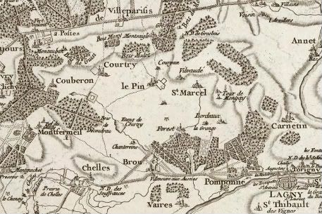
The eponymous map was begun by the Italian astronomer Giovanni Domenico Cassini. Cassini was invited to France by King Louis IV in 1669, where the astronomer became the first director of the Paris Observatory. Developing an interest in the planets, it was here that Cassini would discover the gap in the rings of Saturn which bears his name.
Shortly after his arrival, Cassini - who as a naturalized Frenchman adopted the name Jean-Domenique - began the first topographic survey of an entire country in the 1670s, carefully triangulating distances to produce an accurate map of the Sun King's realm. The project would succeed them both - Cassini's son and grandson would be required to see the surveying and mapping to completion in 1789, when the Carte de Cassini was published.
The map is an amazing record of its time, detailing the names and locations of villages, fortified cities, castles, commanderies of the Knights of Saint John, mills, roads, forests, rivers, marshes and on and on. Pairing it with the contemporary Google map of France allows me to examine land cover in greater detail - the number of features of the current French landscape that can be found in their near identical proportions on the Cassini map is astounding - as well as measure accurate distances between points.
In my experience, there is no fictional roleplaying game map which can hold a candle to it. It is an incredible resource for running a campaign set in 17th or 18th century France, and, if cartophilia's your thing, it's just a kick in the ass to play with.
Subscribe to:
Posts (Atom)