
I've loved maps and charts since I was a kid, pretending for hours that I was navigating my way across the Pacific Ocean or traversing central Asia along the Silk Road. I was a geography major at university and took every cartography course my department offered, and I made resource management maps in my days as a park ranger and resource ecologist, so stuff like this is a gentle caress of my nucleus accumbens.
I make extensive use of historic city maps for my Flashing Blades campaign, but my favorite campaign map by far is an interactive version of the Carte de Cassini.
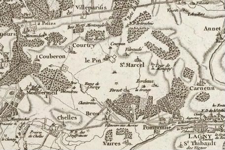
The eponymous map was begun by the Italian astronomer Giovanni Domenico Cassini. Cassini was invited to France by King Louis IV in 1669, where the astronomer became the first director of the Paris Observatory. Developing an interest in the planets, it was here that Cassini would discover the gap in the rings of Saturn which bears his name.
Shortly after his arrival, Cassini - who as a naturalized Frenchman adopted the name Jean-Domenique - began the first topographic survey of an entire country in the 1670s, carefully triangulating distances to produce an accurate map of the Sun King's realm. The project would succeed them both - Cassini's son and grandson would be required to see the surveying and mapping to completion in 1789, when the Carte de Cassini was published.
The map is an amazing record of its time, detailing the names and locations of villages, fortified cities, castles, commanderies of the Knights of Saint John, mills, roads, forests, rivers, marshes and on and on. Pairing it with the contemporary Google map of France allows me to examine land cover in greater detail - the number of features of the current French landscape that can be found in their near identical proportions on the Cassini map is astounding - as well as measure accurate distances between points.
In my experience, there is no fictional roleplaying game map which can hold a candle to it. It is an incredible resource for running a campaign set in 17th or 18th century France, and, if cartophilia's your thing, it's just a kick in the ass to play with.
That is an entirely beautiful map. I'm in love.
ReplyDelete